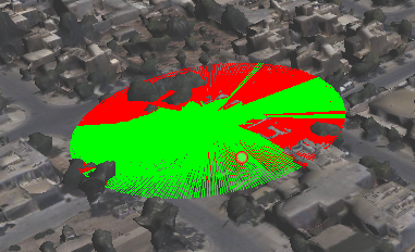
Area of Sight is a set of imaginary straight lines joining the centre of the observer's and other points located at a distance constant from the observer. These set of lines appear as a set of radii with observer as the centre. The Area of Sight command allows you to identify the visible and invisible parts to the observer at a specified distance. The area visible appears is represented by green and area invisible by red.
 |
|
3.
|
If the Map tools pane is not expanded, in the map viewer, click the Map Tools button.
|
|
4.
|
On the Map Tools pane, click the More Tools button and then select Area of Sight. The Area of Sight dialog box appears.
|
|
5.
|
Click the icon next to the View From field, and click a location on the map. The View From field gets populated by the coordinates of the selected location.
|
|
6.
|
Click the icon next to the View To field, and click a location on the map. The View To field gets populated by the coordinates of the selected location.
|
|
8.
|
Click Show. The distance between the specified coordinates is calculated based on which the area of sight is displayed on the map.
|