Getting Started : Downloading OnPoint Map Products and Spatial Data

Downloading OnPoint Map Products and Spatial Data
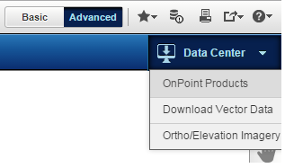
OnPoint enables sharing of spatial data and map products through the Data Center feature. Data Center is a one-stop shop for the users to browse and download the map products, vector and aerial data.
 
Figure 73 
To download map products, vector and aerial data
1.
2.
If OnPoint Products is selected, the Data Center page appears.
For more information on further steps to download OnPoint products, see Download Products.
If Download Vector Data is selected, the Download Vector Data dialog box appears.
For more information on further steps to download vector data, see Download Vector Data.
If Ortho/Elevation Imagery is selected, the Download Ortho/Elevation Imagery dialog box appears
For more information on further steps to download orthophoto/elevation imagery, see Download Ortho/Elevation Imagery.