You can export the currently displayed map or its individual layers to Shape files, MicroStation DGN, AutoCAD file format, or file geodatabase format.
|
1.
|
|
2.
|
|
3.
|
|
4.
|
In Select Format For Exported Data, select the format to which you want to export the file. The following table describes the available format:
|
|
Shape files (.shp) are geospatial vector data files that have been developed by ESRI
|
|
|
Microstation DGN is a CAD file format that has been developed by Bentley for storing design data
|
|
|
An AutoCAD (DWG) file format that is used for storing two or three dimensional design data and metadata
|
|
|
ArcGIS File Geodatabase
|
ESRI file geodatabases (FGDB) are a collection of file folders containing geospatial vector data
|
|
5.
|
Click the Next button.
|
 |
|
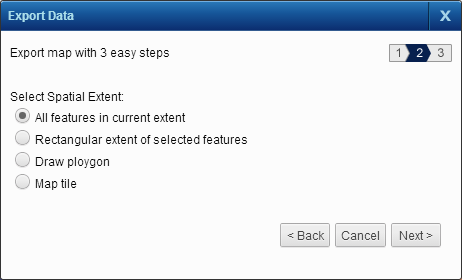
6.
|
You have these options to select the area whose map data you want to export, and then click the Next button:
|
|
All features in current extent
|
Export all selected groups of map features (layers) in the currently displayed area of the map.
|
|
Rectangular extent of selected features
|
Export the complete extent of the selected groups of map features (layers).
|
|
Export the map features whose boundaries fall within or intersect the shape that you draw with the drawing tools. Select one of the map tools and draw a shape on the map covering the area you want to export.
|
|
|
Export the map tile whose number you specify.
Specify a map tile number in the text box that appears and click Go. Optionally click Zoom To to zoom to the map tile on the map viewer.
|
A message is displayed stating that your request (job) has been submitted for processing. After the processing is complete, you can view the file using the Jobs History window. For more information on using the Jobs History window, see Viewing previous task results.